Tolantongo offers 5 hiking trails ranging from a 30-minute family walk along the terraced pools to a demanding 4-hour ascent to the mountain viewpoints. Each trail features distinct landscapes: waterfalls, limestone formations, subtropical vegetation, and aerial views of the canyon that justify every step.
What Hiking Options Exist at Tolantongo?
Tolantongo has 5 hiking trails distributed along the canyon, with distances from 1.2 km to 8.5 km, elevation gains from 80 to 650 meters, and difficulties ranging from easy to demanding. All depart from the park’s central area, near the parking lot.
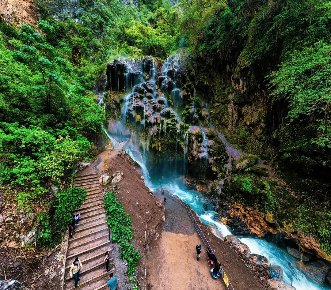
The Tolantongo canyon extends 3.5 km long with walls up to 300 meters high. This geography creates perfect hiking terrain: trails climb the canyon slopes, descend to the river, wind through rock formations, and connect viewpoints with spectacular views.
Summary of the 5 Trails:
| Trail | Distance | Elevation | Difficulty | Time | Best For |
|---|---|---|---|---|---|
| 1. Pool Trail | 1.2 km | 80 m | Easy | 30-45 min | Families, everyone |
| 2. Canyon Viewpoint | 2.8 km | 220 m | Easy-Moderate | 1.5-2 h | Photographers, couples |
| 3. Thermal River Path | 1.8 km | 120 m | Easy | 45-60 min | Families, swimmers |
| 4. Sierra Ascent | 5.5 km | 480 m | Moderate-Difficult | 3-4 h | Experienced hikers |
| 5. Hidden Waterfalls Route | 8.5 km | 650 m | Difficult | 5-6 h | Adventurers, athletes |
All trails are included in the general admission of $230 MXN. You do not need to pay extra or register for any of them, although for trails 4 and 5 it is wise to inform the park staff that you plan to do them and ask about the day’s conditions.
What Is Trail 1: Terraced Pools Trail Like?
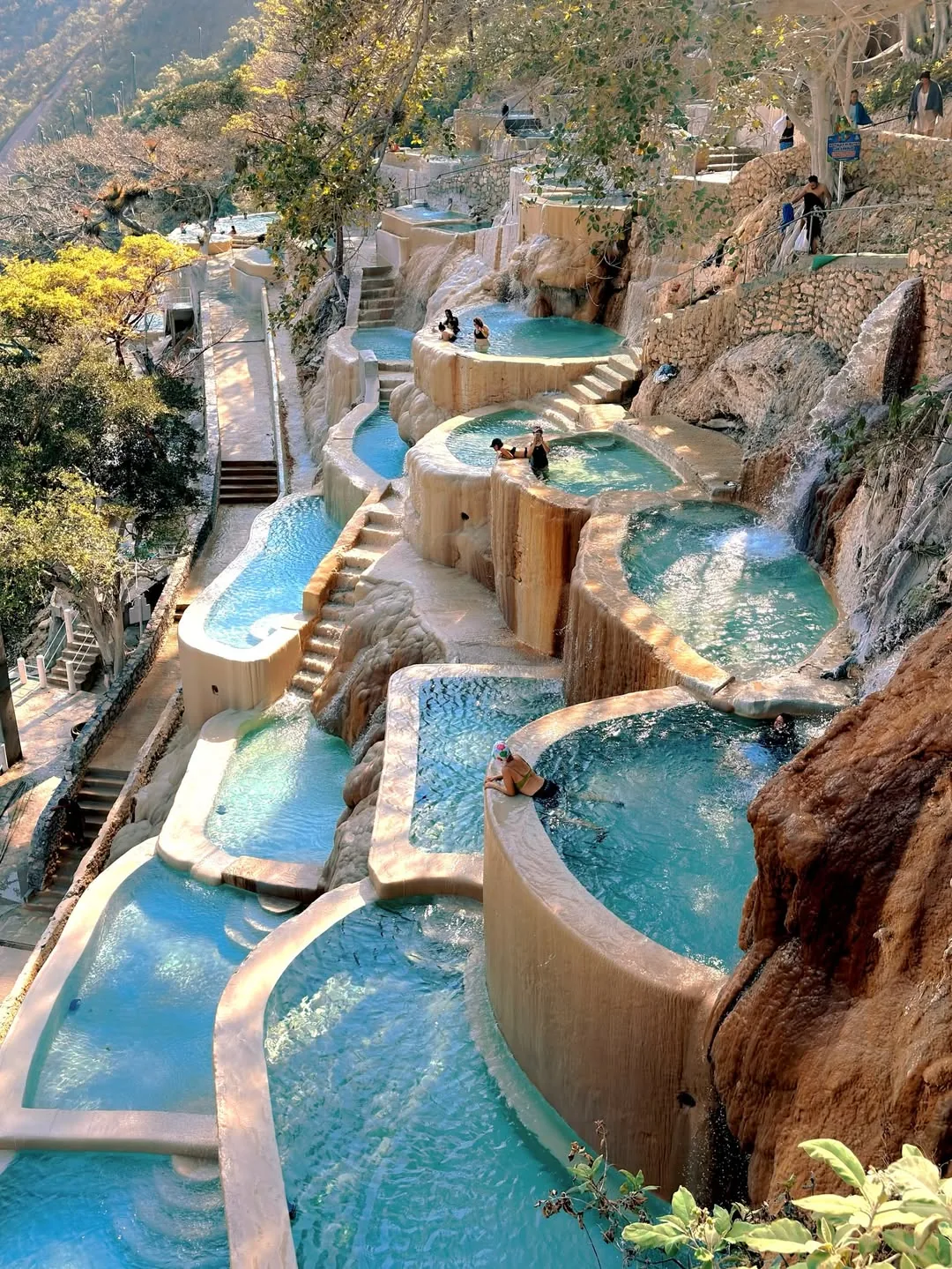
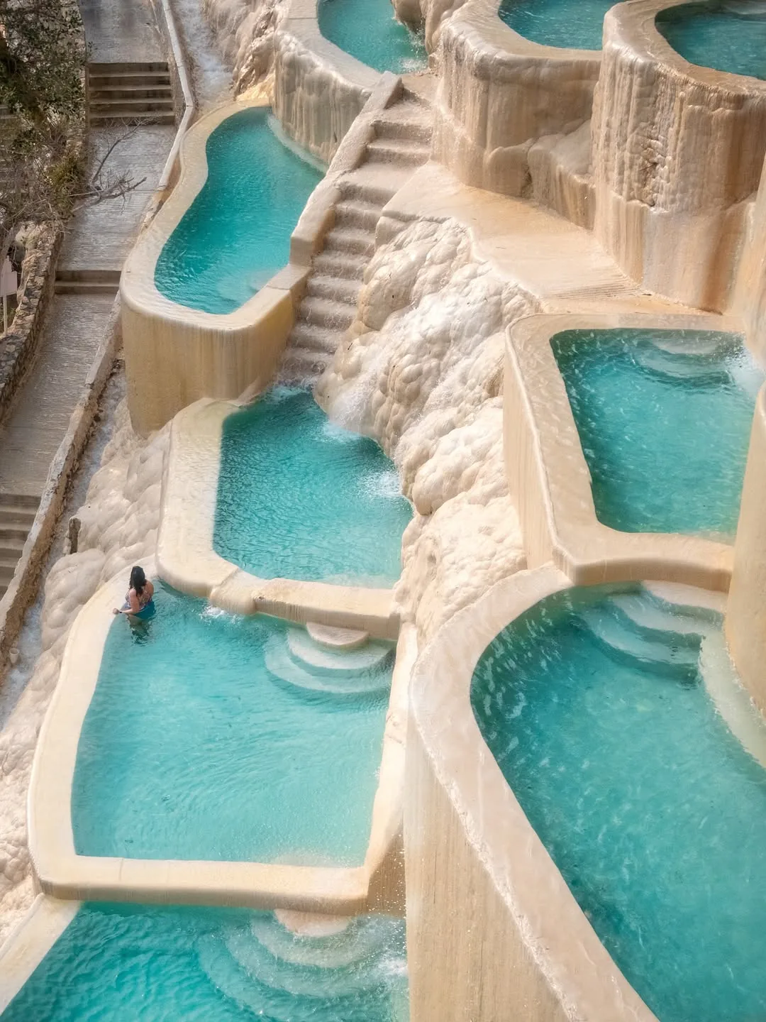
The Terraced Pools Trail is the most popular and accessible walk at Tolantongo: a 1.2 km linear path connecting the 40 stepped pools from the top to the bottom of the canyon, with 80 meters of elevation change and natural stone steps.
Technical Details:
- Distance: 1.2 km (one way), 2.4 km round trip
- Elevation: 80 meters (constant descent)
- Difficulty: Easy (with caution on wet surfaces)
- Time: 30-45 minutes (one way, without swimming stops)
- Starting point: upper pool zone, signposted from the parking lot
- Footwear: non-slip water shoes
This trail is walked by every visitor, though many do not perceive it as hiking but simply as going from one pool to another. But the complete top-to-bottom journey (and back) is a real walk with stone steps, steep sections, and changing views.
What to See Along the Way:
- Pools 1-10 (upper zone): the widest and most temperate, with panoramic canyon views. Depth of 30 to 60 cm. Ideal for families with children.
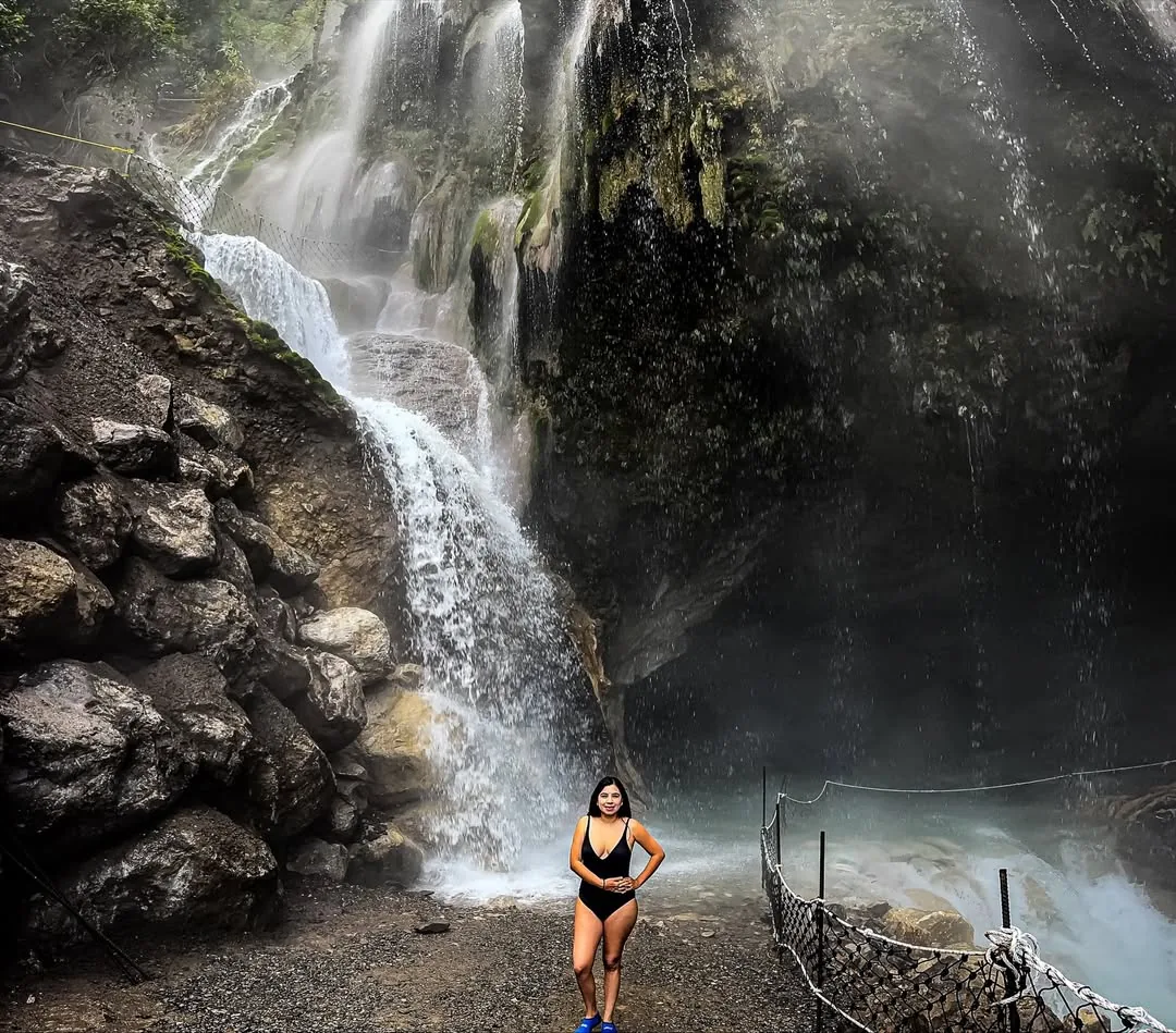
- Pools 11-25 (middle zone): increasing depth (50-80 cm), cascades between pools up to 1.5 meters tall. This is where the steam concentrates, creating Tolantongo’s iconic image.
- Pools 26-40 (lower zone): the hottest (37-38°C / 99-100°F), deepest (60 cm to 1 meter), with the densest canyon vegetation surrounding them. Fewer visitors make it this far.
Tips:
- Go down in the early morning (8:00-9:00) when there are fewer people and sunlight enters the canyon at a golden angle.
- The return (uphill) takes more time and energy than the descent. Plan 30% more time for the climb.
- The steps between pools can be covered with a thin layer of thermal mineral deposit, extremely slippery. Hold onto the handrails where they exist.
- Bring water. Although you are surrounded by thermal water, it is not drinkable, and the combination of heat plus physical activity dehydrates quickly.
What Is Trail 2: Canyon Viewpoint Like?
The Canyon Viewpoint trail ascends 220 meters along the northern slope to an observation point where you can see the entire canyon, the river, the terraced pools, and the 300-meter limestone walls. The 2.8 km trail takes between 1.5 and 2 hours.
Technical Details:
- Distance: 2.8 km (partial circuit with return on the same path)
- Elevation: 220 meters ascent
- Difficulty: Easy to Moderate (sustained grades but no technical sections)
- Time: 1.5-2 hours (round trip)
- Starting point: signposted turnoff next to the administrative offices
- Footwear: athletic shoes with traction or hiking sandals
This is the favorite trail for photographers and content creators. The viewpoint offers an aerial perspective showing the canyon’s scale: the terraced pools look like a jade staircase attached to the mountain, the river winds like a silver line 200 meters below, and the canyon walls reveal geological layers millions of years old.
Trail Profile:
The first kilometer is a moderate climb on a wide dirt path that zigzags up the slope. The average grade is 12%, manageable for most people with regular fitness. The second section (km 1 to 1.4) narrows and the grade increases to 18-20%. Here the path becomes a stone trail with some steps carved into the rock.
What to See:
- Km 0 to 0.5: xerophytic scrubland transitioning to oak forest. Columnar cacti up to 4 meters tall are visible.
- Km 0.5 to 1.0: first partial overlook with a view of the canyon entrance and the mountain road winding below. Good spot for an intermediate photo.
- Km 1.0 to 1.4 (viewpoint): the highest point of the trail. 180-degree canyon view. On clear days, visibility reaches 30 km toward the mountains. Best light for photography is between 7:00 and 9:00 a.m. (golden side light) or between 4:00 and 5:30 p.m. (warm sunset light).
Tips:
- Bring at least 750 ml of water per person. There are no water sources on the trail.
- Use biodegradable sunscreen. The northern slope receives direct sun all morning.
- The return is faster (40-50 minutes) but demands care on the downhill to protect your knees. Use a trekking pole if you have one.
- Not suitable for children under 6 due to the length and sustained grade. Children ages 8-12 complete it without issue if they are used to walking.
What Is Trail 3: Thermal River Path Like?
The Thermal River Path descends 120 meters along the canyon slope to the riverbanks where cold and thermal waters mix, creating natural pools of varying temperatures. It covers 1.8 km of semi-improved trail with stone steps and dirt sections.
Technical Details:
- Distance: 1.8 km (one way), 3.6 km round trip
- Elevation: 120 meters (descent)
- Difficulty: Easy (descent) / Moderate (return climb)
- Time: 45-60 minutes (one way), 1-1.5 hours round trip
- Starting point: near the camping area, signposted
- Footwear: water shoes (you will cross water) or athletic shoes with traction
This trail takes you to a different experience from the terraced pools. The Tolantongo River in its natural course has sections where thermal water springs directly from the riverbed, creating pools where you can sit in 34°C (93°F) water while 2 meters away the river runs at 18°C (64°F). The contrast is unique.
What to See:
- First section (500 m): descent on stone steps through subtropical vegetation. The river sound grows louder as you descend.
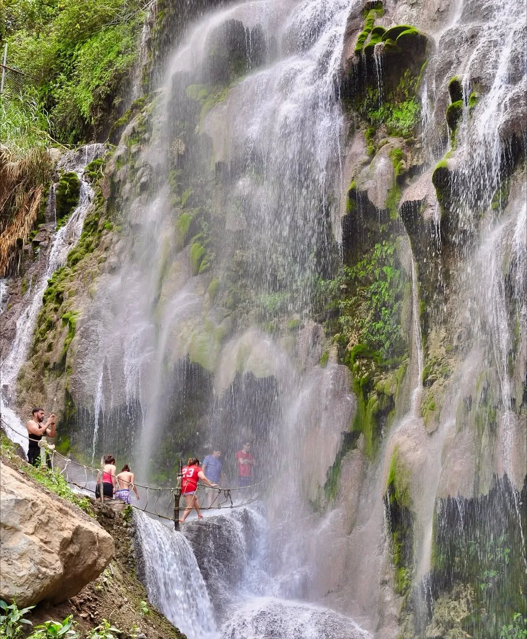
- Thermal waterfall zone: midway along the path there is a thermal waterfall approximately 5 meters high that falls directly from a fissure in the canyon wall. The water emerges at 38°C (100°F) and forms an impressive steam curtain on cold mornings.
- Riverbank: natural pools where cold and thermal waters mix. Some have sandy and gravel bottoms, others rock. Depth varies from 20 cm to over 1 meter.
- Rock formations: canyon walls at river level show limestone layers in tones ranging from white to ochre, with mineral deposits forming stalactites and calcite curtains.
Important Precautions:
- During rainy season (June to September), the river level rises and this trail may be closed. Check with park staff before descending.
- Do not cross the river if the current reaches above your knees. The bottom stones are slippery and the current can sweep you away.
- Carry your belongings in a waterproof bag. The water crossings will soak everything you carry.
- Return before 4:00 p.m. The canyon floor loses light quickly and the trail has no lighting.
For details on river risks and safety, check our updated guide.
What Is Trail 4: Sierra Ascent Like?
The Sierra Ascent is a moderate to difficult 5.5 km trail that climbs 480 meters from the canyon floor to the upper plateau, where a landscape of oak and pine forest opens up with panoramic views of the entire gorge. It requires good physical fitness and 3 to 4 hours.
Technical Details:
- Distance: 5.5 km (one way), 11 km round trip (or 8 km partial circuit)
- Elevation: 480 meters accumulated ascent
- Difficulty: Moderate to Difficult
- Time: 3-4 hours (round trip) / 5 hours (circuit)
- Starting point: behind the upper cabin area, ask staff for directions
- Footwear: hiking boots with ankle support, good traction soles
This trail leaves the usual tourist circuit of Tolantongo and enters Hnahnu community territory. The path was originally a mule trail connecting the canyon floor with the plateau communities. Today it is the most challenging hiking route available within the Tolantongo area.
Trail Profile by Section:
Section 1: Canyon Floor to First Viewpoint (km 0-1.5)
Steep grade (20-25%) on a dirt and stone trail that zigzags up the southern slope of the canyon. Vegetation is dense: subtropical scrubland with cacti, agaves, and thorny bushes. The trail is narrow (60-80 cm wide) and has exposed sections where the slope drops 50 to 100 meters.
First viewpoint (km 1.5, +180 m altitude): view of the canyon from the southern flank. You can see the grotto tunnel entrance, the terraced pools from above, and the main waterfall. Good spot to rest for 10 minutes and drink water.
Section 2: First Viewpoint to Transition Zone (km 1.5-3.5)
The grade moderates (12-15%) and vegetation shifts from scrubland to oak forest. Trees provide shade and the trail widens. There are sections with exposed roots and loose stones. At the 3 km mark you cross a seasonal stream (dry November to May, flowing June to October).
Section 3: Transition Zone to Plateau (km 3.5-5.5)
The final stretch climbs the last 120 meters to the plateau. Vegetation changes to mixed pine and oak forest with a fern understory. The air feels fresh and clean, the temperature is 5-8°C (9-14°F) cooler than at the canyon floor. Upon reaching the plateau (approximate altitude 1,840 meters above sea level), the landscape opens completely.
View from the plateau: the Tolantongo gorge extends like a giant crack in the mountains. Columns of thermal steam rise from the canyon floor. On clear days, the view reaches the Ixmiquilpan plains and the Sierra Gorda mountains.
What to Bring:
- 2 liters of water per person (minimum)
- Energy snacks (bars, nuts, fruit)
- Sunscreen and hat
- Light jacket (the plateau is cooler)
- Trekking poles (recommended for the descent)
- Emergency whistle
- Downloaded map or screenshot of the route
Important: inform park staff that you are doing this trail and ask about the day’s conditions. During rainy season, some sections become muddy and section 1 may have rockfall. Do not attempt this trail if you have no prior mountain hiking experience.
What Is Trail 5: Hidden Waterfalls Route Like?
The Hidden Waterfalls Route is the longest and most demanding trail at Tolantongo: 8.5 km with 650 meters of accumulated elevation that crosses the canyon lengthwise to reach a system of 3 thermal waterfalls that few visitors know about. It requires 5 to 6 hours and high physical fitness.
Technical Details:
- Distance: 8.5 km (linear circuit with return on the same path)
- Elevation: 650 meters accumulated (ascents and descents)
- Difficulty: Difficult
- Time: 5-6 hours (round trip)
- Starting point: river zone, past the main grotto
- Footwear: waterproof hiking boots, you will cross water several times
This is the trail for experienced hikers seeking something beyond the tourist circuit. The path follows the river course upstream, crosses the water at 6 different points, climbs through rocky sections, and reaches a hidden corner of the canyon where 3 thermal waterfalls cascade from heights of 8, 12, and 20 meters onto turquoise limestone pools.
Route Description:
Km 0-2: River section. Walk along the Tolantongo River bank, crossing it 3 times. Crossings have depths of 30 to 70 cm (in dry season). The bottom is rounded, slippery stones. Trekking poles help enormously at crossings. Vegetation is subtropical with giant ferns, wild fig trees, and orchids on the canyon walls.
Km 2-4: Lateral ascent. The trail leaves the river and climbs the eastern slope of the canyon. Sustained grade of 18-22% for 2 km. There are sections requiring hands to scramble up rock steps of 50-80 cm height. This is the most technical section of the route. Vegetation shifts to oak forest and the trail is less defined; look for stacked stone markers (cairns) indicating direction.
Km 4-4.25: Hidden Waterfalls. The trail descends again toward a thermal tributary of the main river. Here are the 3 waterfalls:
- Waterfall 1 (8 m): the most accessible, with a 3-meter diameter pool 1.2 meters deep. Water at 34°C (93°F). Sand and rock bottom.
- Waterfall 2 (12 m): 150 meters from the first, falls over a travertine wall with white calcite formations. The pool is larger (5 meters) but shallower (80 cm). Water at 36°C (97°F).
- Waterfall 3 (20 m): the most spectacular. Falls in two levels over a curtain of moss and mineral. The lower pool is wide and deep (1.5 meters). Water emerges at 37°C (99°F) directly from the rock. The steam it generates creates a microenvironment where tropical ferns and mosses grow that exist nowhere else in the canyon.
Requirements for This Trail:
- Prior hiking experience of at least 10 km
- Physical fitness for 6 hours of walking with elevation change
- Waterproof hiking boots with ankle support
- 3 liters of water per person
- Food for a trail lunch
- Flashlight (in case the trek takes longer)
- First-aid kit
- Whistle and signal mirror
- Do not go alone. Minimum 2 people
Hiring a local community guide ($400-500 MXN per group of up to 5 people) is recommended. Guides know the river crossings, trail conditions, and landmarks that are not marked. Ask at the park offices for available guides.
What Equipment Do You Need for Hiking at Tolantongo?
Equipment varies by trail: the easy trails (1-3) require water shoes, water, and sunscreen. The difficult trails (4-5) demand hiking boots, trekking poles, 2-3 liters of water, food, a first-aid kit, and layered clothing.
Equipment Table by Trail Level:
| Equipment | Trails 1-3 (Easy) | Trail 4 (Moderate) | Trail 5 (Difficult) |
|---|---|---|---|
| Footwear | Water shoes or athletic | Ankle-support boots | Waterproof boots |
| Water | 750 ml | 2 liters | 3 liters |
| Food | Light snack | Bars and fruit | Full lunch |
| Trekking poles | Not needed | Recommended | Essential |
| First-aid kit | Basic | Complete | Complete + splint |
| Extra clothing | Dry t-shirt | Jacket + t-shirt | Rain layer + jacket |
| Flashlight | For the grotto | Recommended | Essential |
| Map/GPS | Not needed | Recommended | Essential (offline) |
| Whistle | Not needed | Recommended | Essential |
Footwear: the most important decision.
For trails 1-3, water shoes with thick rubber soles are the best universal option: they work in both water and on land and weigh little. Hiking sandals like Teva with Vibram soles are the second-best option.
For trails 4 and 5, hiking boots with ankle support are mandatory. The uneven terrain, loose rocks, and steep sections require stability that only boots provide. If trail 5 is done in the wet season, boots should be waterproof (Gore-Tex membrane or similar).
For complete gear, check our what to bring to Tolantongo list.
What Is the Best Season for Hiking at Tolantongo?
The second half of October and November are ideal for hiking: dry trails, green vegetation, temperatures of 12-22°C (54-72°F), low attendance, and clear skies. The rainy season (July-September) makes trails 4 and 5 dangerous due to mud, landslides, and flooding.
Each season affects the trails differently:
October-November (the best):
- Dry trails with good grip
- Vegetation at its greenest from recent rains
- Seasonal streams with water (extra visual appeal)
- Perfect temperatures for walking without overheating
- The 3 liters of water for trail 5 last longer since you sweat less
December-February (very good for trails 1-3):
- Dry and firm trails
- Cool temperatures (6-20°C / 43-68°F) excellent for physical effort
- Very cold early mornings for trails 4-5 (bring layers)
- Dry vegetation on the north slope (less photogenic)
- Shorter days: sun enters the canyon later and leaves earlier
March-May (acceptable):
- Rising heat: in April and May temperatures exceed 28°C (82°F)
- Hydration becomes critical, bring 50% more water
- Dry but dusty trails
- Good visibility
June-September (trails 1-3 only):
- Trails 4 and 5 not recommended: mud, loose stones, landslide risk
- Trail 3 may be closed due to river flooding
- Afternoon rains limit the walking window to mornings (7:00 a.m.-1:00 p.m.)
- Vegetation is the most lush of the year (paradoxically: the best visuals, the worst conditions)
Check our month-by-month season guide to plan your dates.
Can You Combine Hiking with the Thermal Springs?
Combining hiking and thermal springs is the ultimate Tolantongo experience: hike the trails in the morning (7:00 a.m.-12:00 p.m.) and relax in the terraced pools in the afternoon. The thermal water at 36°C (97°F) functions as natural muscle recovery after the hike.
Recommended Combined Itinerary (1 day):
| Time | Activity |
|---|---|
| 7:00 | Arrival and preparation |
| 7:30-9:00 | Trail 2: Canyon Viewpoint (1.5 h) |
| 9:00-9:30 | Rest, hydration, snack |
| 9:30-10:30 | Trail 3: Thermal River Path (1 h) |
| 10:30-11:00 | Swim in river pools |
| 11:00-12:00 | Trail 1: Terraced Pools Trail (full descent) |
| 12:00-1:00 | Lunch |
| 1:00-3:00 | Terraced pools (post-hike relaxation) |
| 3:00-3:30 | Main grotto |
| 4:00 | Change clothes and departure |
This itinerary covers all 3 easy trails and leaves the afternoon for enjoying thermal waters as recovery. The total distance is approximately 5.8 km with 420 meters of accumulated elevation, a moderate day that most people with regular fitness complete without issue.
Recommended Combined Itinerary (2 days, with lodging):
Day 1:
- Morning: Trail 4 (Sierra Ascent, 3-4 h)
- Afternoon: terraced pools + grotto
- Night: illuminated pools (guests only)
Day 2:
- Morning: Trail 3 (River Path) + Trail 1 (Terraced Pools Trail)
- Midday: lunch and final pool session
- Afternoon: departure
For the most ambitious hikers wanting to do Trail 5 (Hidden Waterfalls), it is recommended to dedicate an entire day to it and leave the pools for the second day. The 6 hours of hiking plus time at the hidden thermal waterfalls tire the body enough that a night in a cabin and a day of pools the next day is the perfect combination.
The mineral-rich thermal water (calcium, magnesium, sodium, bicarbonate) acts as a natural recovery bath. Immersion in 36-38°C (97-100°F) water dilates blood vessels, improves circulation, and relaxes muscles contracted from hiking effort. It is no coincidence that many visitors report sleeping deeply after a day combining hiking and thermal springs.
What Safety Rules Apply for Hiking at Tolantongo?
The main rules are: do not leave marked trails, do not hike trails 4-5 after 2:00 p.m., inform park staff if doing long trails, carry an emergency whistle, and respect weather-related closures.
10 Hiking Safety Rules in the Canyon:
-
Do not leave the trail. The canyon vegetation hides cracks, caves, and drop-offs that are not visible. Walking off-trail also damages the canyon’s fragile ecosystem.
-
Do not start trails 4 or 5 after 2:00 p.m. There is no lighting, and being caught on the trail at night in a canyon with no cell signal is a real emergency.
-
Inform the staff. Before doing trails 4 or 5, let the park offices know. If you do not return on time, at least someone knows where to look.
-
Carry a whistle. 3 short blasts is the universal distress signal. Sound carries over 1 km in a canyon due to the sound reverberating off the walls.
-
Do not cross the river in strong current. If the water reaches above your knee or you feel the current pushing you, do not cross. Wait for it to drop or turn back.
-
Respect closures. If park staff close a trail, there is a reason: landslide, flooding, dangerous animal, or maintenance. Do not ignore them.
-
Hydrate constantly. Drink 200-250 ml of water every 30 minutes of hiking. Dehydration in a hot canyon is silent and rapid.
-
Protect yourself from the sun. Trails 2 and 4 have exposed sections where the sun hits directly. Hat, biodegradable sunscreen, and sunglasses are essential.
-
Carry your trash out. There are no trash bins on trails 4 and 5. All trash you generate comes back with you. The canyon is an ecosystem that stays clean only if every visitor takes theirs.
-
Do not feed wildlife. The canyon hosts endemic birds, reptiles, and insects. Feeding them alters their behavior and makes them dependent on human presence.
Tolantongo offers hiking for all levels: from a relaxed walk among pools to the serious adventure of the hidden waterfalls. What makes hiking here unique is the final reward: after every walk, you can submerge in 36°C (97°F) thermal water while gazing at the walls of a 300-meter canyon. There are not many places in the world where nature offers you that.
Frequently asked questions
Can you hike at Tolantongo without a guide?
Yes, trails 1, 2, and 3 (pool trail, canyon viewpoint, and river path) can be done without a guide. The trails are marked and well-traveled. Trails 4 and 5 (sierra ascent and hidden waterfalls route) are more remote and it is recommended to go with a companion or a local guide.
How much does hiking inside Tolantongo cost?
Hiking inside the park is included in the general admission fee ($230 MXN per person in 2026). There is no additional charge for walking the trails. If you hire a local community guide, the cost is approximately $300 to $500 MXN per group, depending on the trail and duration.
What is the best time of year for hiking at Tolantongo?
The second half of October and November offer the best conditions: dry trails, green post-rain vegetation, mild temperatures of 12-22°C (54-72°F), and low attendance. Avoid July to September when trails are muddy and there is a risk of landslides.
What footwear is needed for hiking the Tolantongo trails?
For the easy trails (1 to 3), athletic shoes with traction soles or hiking sandals with a back strap are sufficient. For the moderate and difficult trails (4 and 5), hiking boots with ankle support and Vibram or similar soles are required. Water shoes are ideal for sections that cross water.